Weather live updates: Red heavy rain warning for Northland, residents urged to evacuate if feeling unsafe
Vector anticipating 'busier-than-usual day'
Scott Palmer
Vector has told Aucklanders it is anticipating a busier-than-usual day tomorrow.
Current forecasts show peak winds on Thursday between 11am and 11pm, it said.
"If the wind stays as forecast, we will likely see some weather-related power faults particularly in our more exposed coastal areas or leafy, tree-lined neighbourhoods," it warned.
"We know weather disruptions can be stressful, but please be reassured that our teams have already begun to prepare. We are actively monitoring the situation and have crews ready to respond to any outages as quickly and safely as possible."
Aucklanders should get ready in advance:
- Keep your devices charged as we head into tomorrow.
- Secure loose outdoor items like trampolines and patio furniture.
- Check your medical backup plans if you rely on electricity for critical medical equipment.
- Stay updated with the latest weather information from MetService.
Firefighters specialising in water rescue deployed in Whangārei and Auckland
Katrina
Fire and Emergency New Zealand is deploying 29 firefighters with specialist skills in water rescue and urban search and rescue to Whangārei and Auckland ahead of the incoming storm.
Assistant National Commander Ken Cooper said they're also "actively assessing the risk in Coromandel and the western Bay of Plenty and have up to 16 specialist firefighters ready to be pre-positioned".
He said pre-deployment of resources is evidence based and is carried out in conjunction with lead agencies.
"The severe weather is forecast for a very large geographical area, so we must consider carefully with Civil Defence and Police where to pre-position our specialists.
"We advise people impacted by the predicted bad weather to stay at home but be prepared to move if required. If life or property is at risk, call 111."
Katrina
Severe weather watches
Katrina
Rain watches
MetService has issued a heavy rain watch for Auckland south of Whangaparaoa from 3am tomorrow until noon on Friday.
Taranaki Maunga is under the same watch from 9am tomorrow until noon Friday.
Areas of the Tasman District south of Nelson City and north of Saint Arnaud not under a warning are under the same watch from noon tomorrow to noon Friday.
The inland ranges of Marlborough west of the Seaward Kaikoura Range and south of Picton are under the same watch from 6pm tomorrow until 3pm on Friday.
The Ranges of the Westland District are under the same rain watch from 3pm tomorrow until 3am on Saturday.
North Otago, also Canterbury south of Timaru and east Twizel are under the same watch from 6pm tomorrow until 6am on Friday.
Wind watches
Banks Peninsula is under a strong wind watch from 7pm tomorrow until 7pm on Friday.
Coromandel Peninsula and Waikato are under the same watch from 9am tomorrow until 8am Friday.
Taupo, Taumarunui, Taihape, Whanganui, South Taranaki are under the same watch from noon tomorrow until noon Friday.
Northland Civil Defence urges residents to prepare grab bag and evacuation plan
Katrina
Severe weather warnings
Katrina
A deep sub-tropical low is approaching New Zealand in the coming days, with heavy rain and strong northeast winds spreading to many regions from late today until Friday.
MetService said this will be an “impactful multi-hazard event”.
Red warnings
There is currently a red heavy rain warning for Northland east of Kaikohe from Doubtless Bay to Whangārei. This warning is valid until 4am Friday.
Orange rain warnings
An orange heavy rain warning is in place for the remainder of Northland until 4am Friday.
Great Barrier Island is also under the same warning from 3am tomorrow until 9am Friday.
Auckland from Whangaparāoa northwards is also under the same warning from 3am tomorrow until 9am Friday.
The Coromandel Peninsula is under the same warning from 6am tomorrow until 6pm Friday.
The Bay of Plenty west of Whakatāne is also under the same warning from 9am tomorrow until 3am on Saturday.
Tasman west of Motueka is under the same rain warning from 10am tomorrow until noon on Friday.
The Richmond and Bryant Ranges are under the same warning from 6pm tomorrow until noon on Friday.
Wind warnings
A strong orange wind warning is in place for Northland from 9pm tonight until 11pm tomorrow.
The same warning is in place for Auckland and Aotea Great Barrier Island from 8am tomorrow until 2am on Friday.
Katrina
Rain radar shows Northland blanketed in rain
Katrina
Katrina
‘Treacherous’: SH2 Waioweka Gorge may close due to wild weather
Katrina
The national transport agency is advising motorists that a severe weather warning is in place for areas west of Whakatāne tomorrow, which may make driving “treacherous”.
State Highway 2 through the Waioweka Gorge may be closed at short notice if conditions deteriorate and it becomes unsafe for travel.
NZ Transport Agency Waka Kotahi (NZTA) said while areas to the east are not currently affected, weather conditions may change quickly.
The situation will continue to be assessed as the forecast is updated.
Katrina
Bay of Plenty District Council warns landslides can happen quickly and without warning
Katrina
Bay of Plenty District Council said that with the January storm still fresh in everyone’s minds, people need to be aware that the ground remains unstable in places.
"Even though the surface may have dried out, previous slips often leave behind weakened soil and disturbed layers.
"When rain falls, water can seep into these areas, reducing the soil’s strength and increasing the risk for further movement," the council said.
MetService said 200-250mm of rain is expected in the area, with peak rates of 15 to 20mm per hour. The worst of the weather is expected on Friday.
“If you live near, are visiting, or driving through areas which may be prone to landslides, please stay alert and aware,” Bay of Plenty District Council said.
The local council said landslides can happen quickly and without warning.
“If you see signs of a potential landslide, please act quickly – evacuate the building, or move away from the area,” it said.
Bay of Plenty District Council is actively monitoring the weather system alongside regional partners and is ready to respond if necessary.
Warning signs include:
– Small slips, rock falls, and sinking land, at the bottom of slopes.
– Sticking doors and window frames, which may mean the land is slowly moving under the building.
– Gaps where window frames are not fitting properly.
– Steps, decks, and verandas, moving or tilting away from the rest of the building.
– New cracks or bulges on the ground, road, footpath, retaining walls and other hard surfaces.
– Tilting trees, retaining walls or fences.
Northland residents feeling unsafe as a significant storm nears are being advised to evacuate today if they can, during daylight hours.
A red heavy rain warning has been issued for parts of Northland, with MetService describing the incoming weather as an “impactful multi-hazard event”.
The warning is in effect until 4am Friday and covers the area east of Kaikohe from Doubtless Bay to Whangārei, with MetService warning that dangerous river conditions, significant flooding and slips could bring a threat to life.
In an update posted online, Whangārei District Council said its important people consider their own situation and exposure to landslides and flooding.
It said people in the Whangaruru North and South area whose homes were impacted by flooding and land slips in the January weather event, and who don’t feel safe, are advised to leave today to a safe location either with family and friends or to a local marae.
“We are advising people to leave today, ideally during daylight hours.”
The council said there will be no pilot service on Kaiikanui Road and people should restrict all non-essential travel, tomorrow especially when the worst of the weather is due to hit.
“If you must travel on Kaiikanui Road during this weather event, take extreme care, travel during daylight hours if possible and keep your speed below 30km. If you can, take the alternative route out via Opua.
“If you are feeling unsafe in your home and choose to leave, remember to take a grab-bag with 4-5 days’ worth of clothes, medicine and whatever else you need to be away from home, including your pets.
“If you are in danger, call 111.”
Two days of wild weather
The deep sub-tropical low approaching New Zealand will bring heavy rain and strong northeast winds for Northland, Auckland, Coromandel and Bay of Plenty from late today through tomorrow and Friday.
MetService said to expect 270mm to 320mm of rain with peak falls of 25mm/h to 40 mm/h and possibly greater from Thursday afternoon through to early Friday morning.
The remainder of Northland, Auckland and Great Barrier Island have had orange warnings for wind and rain issued.
Auckland Emergency Management has warned residents to run through their get-ready checklist.
“We are sandwiched in between the regions forecast to bear the brunt of this front, but we still need to be prepared for some heavy rain and nasty conditions,” it warned.
“Check your household emergency plan is up to date.”
Meteorologist Silvia Martino told the Herald rain would start spreading south into Northland this afternoon.
“The rain starts to get heavy in the evening and it really is a long period of heavy rain for them,” she said, warning of consistent rain “for a couple of days”.
Landslide risk
MetService said the heaviest rain was likely in the upper North Island, especially from Northland to western Bay of Plenty.
“Downpours, flooding, and slips are possible on Thursday and Friday.”
The Bay of Plenty District Council said that with the January storm still fresh in everyone’s minds, people needed to be aware that the ground remains unstable in places.
It said even though the surface may have dried out, previous slips often leave behind weakened soil and disturbed layers.
“When rain falls, water can seep into these areas, reducing the soil’s strength and increasing the risk for further movement,” the council said.
The local council said landslides can happen quickly and without warning.
“If you see signs of a potential landslide, please act quickly - evacuate the building, or move away from the area,” it said.
Heavy rain warnings are also forecast to come into force for Great Barrier Island and the Coromandel Peninsula from early tomorrow morning until Friday night.
Martino said the rain would begin to move across Auckland today; however, the heaviest rain would drench the city tomorrow and into Friday.
The wet weather will continue to spread southward tomorrow, with the Coromandel and Bay of Plenty set to be drenched in the morning, Martino said.
An orange heavy rain warning comes into effect for the remainder of Northland, not under the red warning, from 4pm today until 4am on Friday.
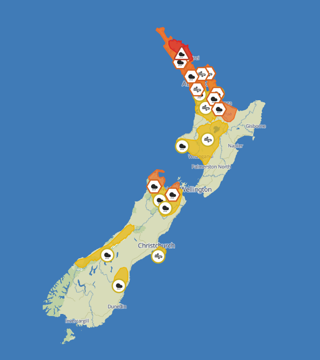
An orange strong wind warning has been issued for Auckland and Great Barrier Island from 8am tomorrow until 1am on Friday.
Bay of Plenty west of Whakatane will be under an orange rain warning from 9am tomorrow until 3am on Saturday.
A Bay of Plenty Civil Defence spokesperson said they were actively monitoring the situation.
“We’re working closely with local councils and the Bay of Plenty Regional Council Flood Room.
“We urge communities to take care if they’re out and about as heavy rain may lead to surface flooding, slips and difficult driving conditions.
“Streams and rivers may also rise quickly, so please avoid low‑lying areas and remain cautious."
Several other parts of the North Island, including Waikato and Taranaki, have had wind and rain watches issued.
In the South Island, rain warnings for Tasman west of Motueka as well as Richmond and Bryant Ranges will come into effect tomorrow, while several watches have been issued across the island.
Powerful winds were forecast to bring heavy swells to coastal areas.
“Expect heavy swells with heights exceeding 4m to affect coastal areas of the North Island from Wednesday night,” MetService said.
“Later in the week, big waves will affect the South Island, with swell heights possibly exceeding 6m, especially in the western coastal areas.”
NZ Transport Agency Waka Kotahi (NZTA) warned motorists of possible disruptions to travel on the Auckland Harbour Bridge as high winds are forecast between 9pm tonight and 9am Friday.
Winds “may force lane closures and additional short periods of full closure to ensure safety”, said NZTA.
The strongest gusts, some potentially blowing at 120km/h, are expected to hit overnight on Thursday.
The transport authority advised drivers of high-sided vehicles and motorcyclists to avoid the bridge and use the western ring route on State Highways 16 and 18.
Civil Defence Northland said residents should prepare for the incoming weather.
Recommended action included:
The organisation said it was monitoring the situation and positioning resources across the region so it could respond effectively if needed.
NZTA Northland journey manager Kingston Brands said Northland motorists should take care on the roads.
“Strong winds and prolonged rain mean drivers should expect possible disruption and plan accordingly”.
Brands said Whakapara, Kaeo, and Rangiahua are common spots for surface flooding where drivers should take extra care travelling through.
“We are urging people to drive to the conditions and consider delaying non‑essential travel during heavy rain. Do not drive through floodwater and follow all road signs and instructions, noting ongoing road works will also be on parts of the state highway network.”
NZTA said motorists are being advised that a severe weather warning is in place for areas west of Whakatāne tomorrow, which may make driving treacherous.
State Highway 2 through the Waioweka Gorge may be closed at short notice if conditions deteriorate and it becomes unsafe for travel.
Sign up to The Daily H, a free newsletter curated by our editors and delivered straight to your inbox every weekday.