New Auckland map shows off region's comparable size to 12 largest regions
Wednesday, 28 August 2019
Auckland is known for a lot of things - bad traffic, expensive homes, and usually being the only stopover for international acts.
But the amount of Kiwis living there was the latest map-themed talking point, as a new map put the city's population into perspective.
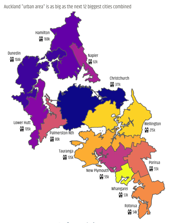
According to Stats NZ data from 2018, one in three Kiwis were living in the big city. It also had the same population of 12 urban New Zealand areas combined, including the capital, Christchurch, Dunedin and Rotorua.
The city's main urban area could house Wellington's 215,000 people, Christchurch's 377,000, and Hamilton's 169,000, as well as the total populations of Napier, Dunedin, Tauranga, Palmerston North, Lower Hutt, New Plymouth, Whāngārei, Rotorua, and Porirua.
**READ MORE:
* Record building activity in Auckland with 10,000 dwellings approved in 2018
* Marina development objectors silenced
* Sailing club's storm damage costs could be up to $100,000
* New bus network starts in two months**

.nsImageWrapper {position: relative; box-sizing: border-box; width: 100%; margin: 15px auto; max-width: 960px; font-family: 'Merriweather Sans','Open Sans',Helvetica,Arial,sans-serif; color: #333;} .nsImageWrapper img {width: 100%; border-style: none;} .nsImageCredit {font-size: 10px; text-transform: uppercase; color: rgb(162, 174, 180); text-align: right; font-style: normal; height: 1em; display: block; width: 100%; font-weight: 300;} .nsImageCaption {width: 100%; font-size: 14px; font-weight: 300; text-align: left; border-bottom: 1px solid rgb(235, 238, 240); padding: 0.8em 0 .58824em; line-height: 1.41176em; color: rgb(115, 120, 123); text-size-adjust: 100%;} @media only screen and (min-width: 841px) {.nsImageWrapper {font-size: 15px; font-size: 0.88235rem;}} @media only screen and (min-width: 300px) {.nsImageWrapper {font-size: 13px; font-size: 0.76471rem;}}
DAVID FRIGGENS/INFOMETRICS
The map, created by David Friggens and published on Infometrics, showed the 12 most populated cities in New Zealand, excluding Auckland, pieced together to cover Auckland's urban area.
A second graphic highlighted the size of six other urban Auckland regions and compared them to other regions of the same size.
Nelson and its population of 49,000 was put in place of the Hibiscus Coast, Carterton's 5000-person population replaced Warkworth, Wanaka's 9,000 filled the space of Waiheke West, Beachlands-Pine Harbour was replaced by Kaitāia, Pukekohe with Taupō, and Waiuku with Hāwera.